Posted on:
15th March 2017 in Categories Ilustration 1
Giving instructions can be tricky, especially when you don’t know the recipients frame of reference. This is true also of giving directions when the starting point is not known. That was the problem in the brief for this exercise and it made me tackle questions of scale and level of detail.
I started with the decision that I would not give directions to my house as I publish on line, so this was for safety considerations. Next I made a list of steps I would need to convey:
arrive in U.K. from anywhere in the world
Follow M56 to Wales
Follow A548 to Bagillt
Turn left on to Bagillt High Street
Turn right on to Gadlys Street
Several formats came to mind for the instructions including a comic strip, a spiral of instructions (landing airplane), a treasure map. So I made some sketches and mocked them up but wasn’t happy with any of them.
Really rough sketching of intial ideas
Floating 3D view of North Walesto-bagillt-01
Zoomed out view of World showing one route to the library.
The mixture of scales in the first idea caused a lack of clarity at the library end of the journey. It also was confusing, due to being ‘upside down’ with no compass to indicate this. The second idea was clearer regarding the actual journey but still confusing at the library end. At this point I realised that neither directions would be of any use to someone traveling from somewhere in Wales. It would be reasonable to expect someone travelling from further away to locate the main roads or indeed bus routes into town. As such I decided to concentrate on the actual location of the library and provide information within the image as to how it linked up to the rest of the area.
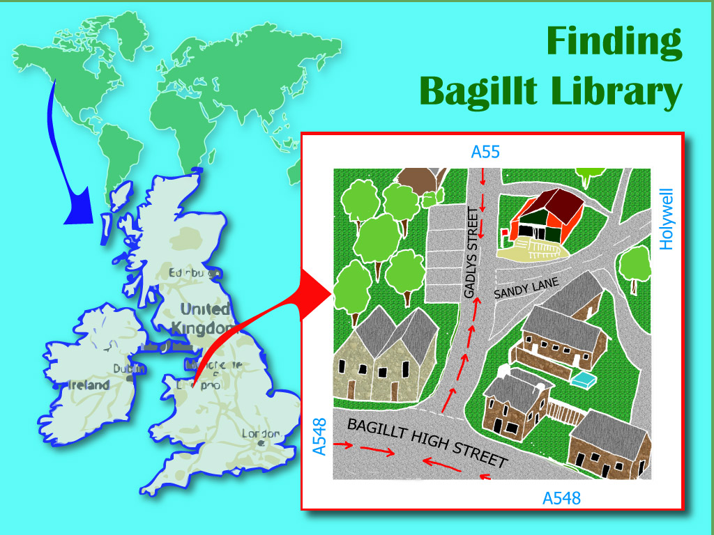
Aerial view of the junction to Bagillt library facing SouthSo I drew the following map, using a Google aerial view as reference but (you can probably tell) making up the angle to suit. I felt it was important to show the face of the library and have used colour and placement to give it focus along with the direction arrows. This has resulted in an ‘upside down’ map but I feel the inclusion of a compass gives detail needed to anyone who can read maps.
I like the final illustration although I do not think it would represent clear instructions for someone living in China. On balance, the probability of needing to give directions to Bagillt library is likely to be skewed in favour of residents of Wales rather than of China! Technically, I still need to improve my linework.
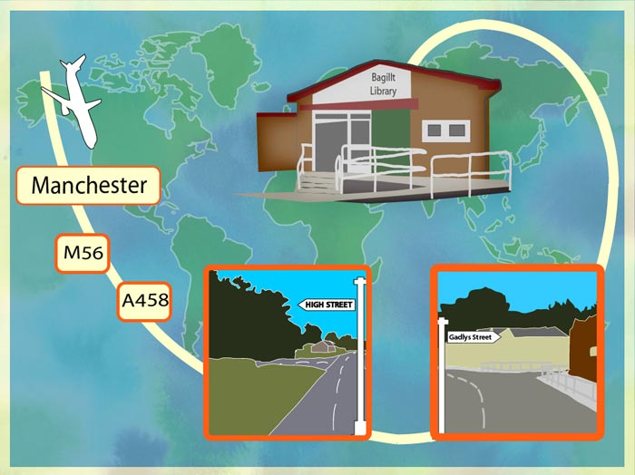
Update Following Feedback
I agreed with my tutor’s suggestion to include more of the layered directions and have included maps at different levels of geographical proximity to the target. I have used colour in this version to help the viewer identify the destination.
Assignment 5 - Seven Days 17th September 2017 The final course assignment is here and it's a very open brief. We are asked to create a series of seven illustrations, illustration strip or…
Travel Guides 20th July 2017 There is no excerpt because this is a protected post.
Top 5 Art Journaling Prompts to Use and Reuse 26th March 2019 When I first started art journaling I was always looking for ideas to inspire my art journal page spreads. I used poems, inspirational quotes, a…
Currently only dispatching to U.K. addresses. Sorry for the inconvenience. Ceri xx
Manage Cookie Consent
I use cookies on this site to find out basic things about visitor traffic, nothing personal. Some features of the site depend on cookies to work properly. In the future you May see adverts for this site on Google or Facebook.
Functional
Always active
The technical storage or access is strictly necessary for the legitimate purpose of enabling the use of a specific service explicitly requested by the subscriber or user, or for the sole purpose of carrying out the transmission of a communication over an electronic communications network.
Preferences
The technical storage or access is necessary for the legitimate purpose of storing preferences that are not requested by the subscriber or user.
Statistics
The technical storage or access that is used exclusively for statistical purposes.The technical storage or access that is used exclusively for anonymous statistical purposes. Without a subpoena, voluntary compliance on the part of your Internet Service Provider, or additional records from a third party, information stored or retrieved for this purpose alone cannot usually be used to identify you.
Marketing
The technical storage or access is required to create user profiles to send advertising, or to track the user on a website or across several websites for similar marketing purposes.


There are no comments yet ... go on, be the first!